

Space for a Safer Life: Using Satellite Data to Measure Air Quality on the Ground
- RefMap

- Jan 26
- 4 min read
Updated: Jan 27
Editor's note: With the RefMap Project concluding on 30/1/2026, the following post was written by RefMap partner S[&]T to provide an overview of their work and results in the project.
In recent years, the issue of air quality has emerged as one of the most pressing environmental challenges of our time. Poor air quality is not just an environmental concern; it is a significant public health issue linked to millions of premature deaths worldwide each year.
The pollutants present in the air, such as particulate matter (PM2.5 and PM10), nitrogen dioxide (NO2), sulfur dioxide (SO2), and ozone (O3), can lead to respiratory diseases, cardiovascular problems, and other adverse health effects. Moreover, these pollutants contribute to environmental degradation, including acid rain, eutrophication, and climate change.
An important contributor to air pollution is the aviation industry. Aircraft engines emit a variety of pollutants, including NO2, SO2, and particulate matter, which can have substantial impacts on local air quality, particularly around airports. The rapid growth of air travel has led to increased emissions, exacerbating the challenges of maintaining healthy air quality standards.
Accurate and comprehensive data on air pollution levels are crucial for understanding the sources and distribution of pollutants, assessing their impact on human health and the environment, and developing effective strategies to mitigate their effects. Traditional ground-based monitoring stations have long been the primary source of air quality data. However, these stations are often limited in their coverage, and can be expensive to maintain.
This is where satellite-based measurements come into play. Satellites can offer a unique vantage point to monitor air quality on a global scale. They provide continuous data that can cover vast geographical areas, including regions where ground-based monitoring is sparse or non-existent.
Unfortunately, satellite data also has a downside: it has limited temporal and spatial resolution, making it difficult to assess the effect that pollution has on local air quality. Here, we delve into how we try to overcome this problem in the RefMap project using the AIR-Portal technology developed by consortium partner S[&]T.
How does AIR-Portal work?
Air quality conditions can change significantly on local scales, due to pollution sources such as domestic heating, traffic emissions during rush hours, or – the focus here – flights arriving and leaving from an airport. At the same time, background conditions can vary significantly due to pollution transport from larger distances, such as from industrial areas. Also, occasionally large-scale events such as dust outbreaks or wildfires can lead to significantly enhanced pollution.
Therefore, to be able to describe air pollution on a local (100 meter) scale requires an approach where many data sources, describing pollution levels on various temporal and spatial scales, are combined.
The basis for the AIR-Portal is data from the Copernicus Atmospheric Atmosphere Monitoring Service (CAMS), which provides hourly atmospheric data with a resolution of about 7x7 km. The additional data used in the down scaling model are regional meteorological model forecasts, and a local, static component which includes land use information, as well as local observations to calibrate and validate the system. The outline of the method is illustrated in Figure 1.

After collection of the necessary input data, the first step is the application of a land use regression scheme to derive a first estimate for the local-scale air quality forecast. The basic concept is that the atmospheric data from CAMS are downscaled towards resolutions of 100x100 m2 using geo-referenced data for the land use types (vegetation, water bodies, various types of urban fabric etc.).
The next step in the procedure is the advection of pollutants by the wind. Finally, calibration of the model aims at optimizing the model behavior by operationally employing an automated routine which has access to the historical archive of model runs, as well as available measurements and will re-evaluate the land use scaling factors based on a statistical evaluation of past forecasts against available measurements (for more details, see this paper).
The results
The results of the AIR-Portal model are hourly maps with a resolution of 100x100m for the following pollutants: O3, NO2, SO2, PM10 and PM2.5. An example of such a map is shown in Figure 2.
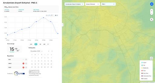
During the development of the model, the data quality of the system was validated. Comparisons of the AIR-Portal approach with measured values show the added value of the approach for downscaling coarse scale models for the urban/local scale environment. The main added value of AIR-Portal is the downscaling step: AIR-Portal data has a resolution of 100m, compared to 5-10km for CAMS. This in particular impacts pollutants with a strong primary component such as NO2.
Moreover, the benefits of using AIR-Portal as a means of downscaling and refining coarser resolution models is confirmed by the performance of the system near strong emission sources (e.g. in the vicinity of the city road network) as established by the evaluation at using measurement stations near major roads. Unfortunately, the modelling results for SO2 (an important aviation pollutant) were found to be not improving with respect to CAMS, likely due to the lack of ground-based measurements for calibration. More research is needed to improve the results for this species.
Conclusion
In order to study the effect of aviation on local air quality across Europe, data sets are needed that are available in a many places, independent on the availability of ground-based measurements. We have shown that satellite data can successfully be downscaled to high spatial resolutions. Although more research is needed to fully capture all effects of aviation on local air quality, this activity does show the unique added value of satellite data for large scale, objective air quality assessments.


